Soreng report on Plummers Island flooding 2 March 2021.
” I wanted to see what things looked like at 9ft flood and to learn more about the wetland on the west side of the bridge.The flood stage is 9 ft at Little Falls Gauging Station. This is still below the “Minor” 10 ft flood stage, 12′ is Moderate, 14″ and above is Major.
I started at walking from Lock 10, first pic is at Rock Run Culvert (the real one),
then walked down to the channel from Lock 13 along the American Legion Bridge east side trail.
Began photographing at the bridge culvert.
RE the large wetland on the west side of the bridge, my impression is that it is an impoundment wetland, created by the bridge construction, not natural. The outflow was barely a trickle today (cut on west side of bridge), and lower down the only water in the stream cut was back-water from the river flood. The impoundment meadow is too high above the river to get Potomac floodwaters except in massive floods like 1996. The volume of the outflow on the ST vegetation survey map seems to be incorrect. at the top there was no more than a trickle, at the bottom it was all backwater from the river. It cuts to under the bridge between the lowest and 2nd from lowest pier set, but I’ve never seen this flow. This was all underwater today, from the 2nd row of piers down.
From there, after photographing the channel and tip of the island (Rock of Gibraltar), I proceeded back down channel to the Plummers Island sign. (one last shot is the trail jct. down from lock 11 at the river edge). One thing you’ll notice overall, is there are no exposed embankments as all are underwater.
Along the way I had to detour up to the beech forest as access along the channel paths was mostly underwater. I found a WBFC/NPS cap stake (seen it before), old boundary of WBFC property and fence line along the way.
The channel varied from 40 to 60+ ft wide today. The log jam at the dog leg is gone (good news; but there are probably more logs on the way).
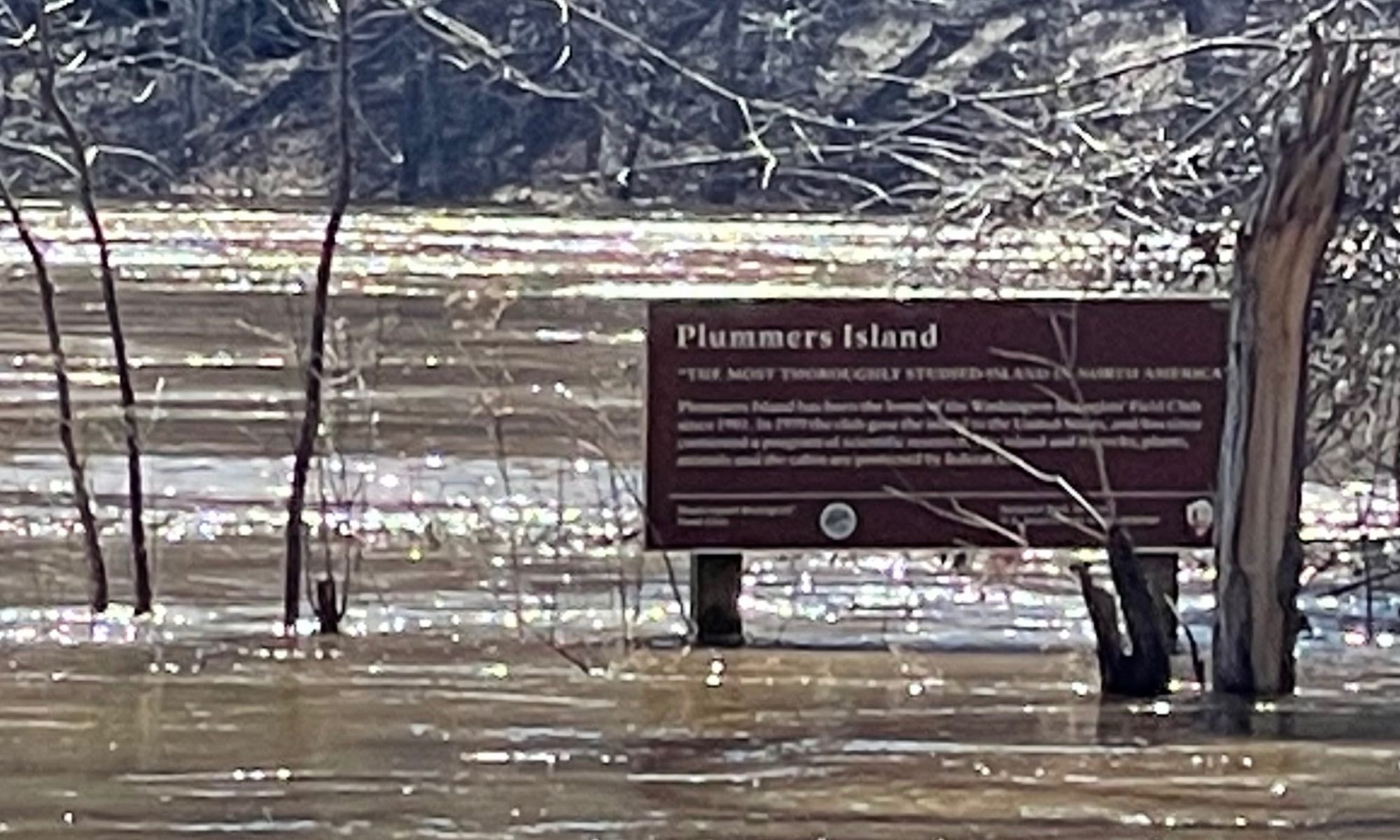
At 9 ft flood stage the long channel side bench / barrens / Island main floodplain was only slightly breached except below veg. plot 9 (big sycamore), where the bottom of the PI sign was only ca 6 inches above the flood line. (at 10 ft, it would be breached, at 11 ft, most of the floodplain would be submerged), at 1996 levels the Island would appear as two islands.”
Images are on Google Pictures
key to photosIMG_1921 Rock Run Culvert (reconstructed below Lock 11)
IMG_1922 Channel dog leg
IMG_1923 Channel dog leg down stream view
IMG_1924 Channel dog leg down stream view
IMG_1925 Channel dog leg up stream view (along ALB)
IMG_1926 Channel dog leg up stream view (along ALB)
IMG_1927 Impoundment meadow, west side of ALB
IMG_1928 Impoundment meadow, west side of ALB wide view
IMG_1929 Outflow from Impoundment meadow
IMG_1930 Outflow from Impoundment meadow 2
IMG_1931 Under ALB lower two rows of piers and Potomac River in spate
IMG_1932 Top end of Channel
IMG_1933 Rock ridge straight across channel from previous view, shadow of ALB
IMG_1934 Downstream view from previous view
IMG_1935 View of left two piers from 2nd row of piers
IMG_1936 View of left two piers from 2nd row of piers
IMG_1937 View of lower end of cut from Impoundment meadow outflow (filled only from backflow from the river)
IMG_1938 View of previous drainage up the cut (again filled only from backflow from the river)
IMG_1939 View of lower end of cut from Impoundment meadow outflow (filled only from backflow from the river)
IMG_1940 Western most point of Plummers Island, Rock of Gibraltar in backgroud, vegetation plots 4 & 5 under water in foreground, Point of Rocks submerged in the river
IMG_1941 WBFC NPS property boundary marker and old WBFC fence (south towpath ca 30 m near Lock 12)
IMG_1942 WBFC NPS property boundary marker (south towpath ca 30 m near Lock 12)
IMG_1943 Frog ponds on Mainland, well above the flood
IMG_1944 View down from Frog ponds on Mainland to the channel
IMG_1945 Frog ponds on Mainland, well above the flood, view 2
IMG_1946 Back down to the channel view of Cabin Hill
IMG_1947 Back down to the channel view of Cabin Hill, closer up
IMG_1948 Back down to the channel view of east end of Cabin Hill, downstream view
IMG_1949 Back down to the channel view of east end of Cabin Hill, further downstream view
IMG_1950 Further down channel view of Cabin Hill
IMG_1951 Vegetation plot no. 1 flags in floodplain below Cabin Hill
IMG_1952 Vegetation plot no. 11 flags on embankment above submerged mud flats plot 12
IMG_1953 Vegetation plot no. 10 flags along lower trail
IMG_1956 Plummers Island sign at 9 ft flood stage
IMG_1957 Wide view of lower rock crossing and Plummers Island sign at 9 ft flood stage
IMG_1958 Another view of lower rock crossing and Plummers Island sign at 9 ft flood stage
IMG_1959 View of riverside trail junction with trail to Lock 11